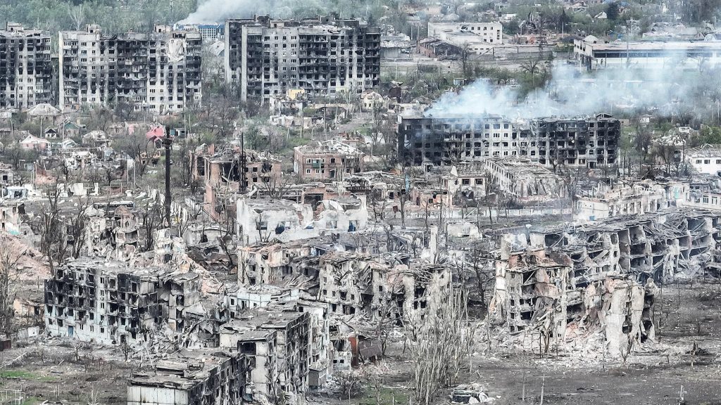
The city of Bakhmut is in ruins as a result of the Ukraine war. Once a city of 75,000 people it has been totally destroyed. No one remains. One of 100s of Ukrainian towns equally destroyed.
5 June 2024 — When I was in Israel last week, I spent some time with my technology contacts and several of my OSINT contacts to see their analysis of the widespread devastation to Gaza’s citizenry, infrastructure and environment, much of it through utilizing publicly accessible satellite imagery that lays bare the scope of the destruction.
Utilizing open-source military intelligence data and satellite imagery, plus artificial intelligence tools, they could visualize the effects to Gaza over the last 8 months of war. They use synthetic aperture radar (SAR) satellite data – which can be used to monitor natural disasters when access is impossible – to give researchers a view of the ground, allowing them to see how quickly a city could be destroyed. Different from optical sensors, SAR transmits electromagnetic waves and records the signal reflected back from Earth, regardless of sunlight and clouds. The reflected waves can be used to evaluate damage during natural disasters and war alike.
So they were able to take images of Earth from space where you can see clusters of city lights and bustling human activity, and then compare it to historical footage, such as this overview photo of Gaza:

Gaza: photo on the left was shot on 1 September 2023, and the one on the right was shot on 1 March 2024.
The same thing has been done for Ukraine after 2+ years of war, but at a higher and more sophisticated level – the sheer amount of data being generated during the war allowing in-depth analysis at the city, regional and national level. And aided by the fact that you can get near-real-time information about the war thanks to social media, unlike with traditional media.
As I have written before, a big revolution in the Ukraine War is the evolving “war of information”. There has been an enormous community that’s formed online which is documenting the war in excruciating detail: artillery and troop movements, damage to civilian infrastructure, power grids and the movement of the front lines. They are helping counter the misinformation that combatants are spreading elsewhere.
What has been most intriguing to me are the time-lapse videos of the satellite images created by research teams that show just how rapidly destruction spreads within the city under siege. One researcher I spoke with told me:
We look at the processed images and we see the end result. We saw what looked like a checkerboard or mesh. I asked my colleague “Why the hell is that?”, and we realized that it’s only the roads that survived. Everything else was collapsed, destroyed, evaporated, the entire city has been completely flattened. War. Jesus Christ.

In a rather astonishing, first-of-its-kind, report the New York Times has put together all of this type of analysis to assess the damage in Ukraine.
Its conclusion? Even if the war ends tomorrow, in many places there will be nothing to go back to. The scale is hard to comprehend.
More buildings have been destroyed in Ukraine than if every building in Manhattan were to be leveled four times over. Parts of Ukraine hundreds of miles apart look like Dresden or London after World War II, or Gaza after half a year of bombardment.
This is the first comprehensive picture of where the Ukraine war has been fought and the totality of the destruction.
Using detailed analysis of years of data, the researchers developed a record of each town, each street, each building that has been blown apart.
The article is quite interactive and it was free for awhile, and now seems to have popped back behind the New York Times pay wall. Here are some links.
Here is a link to a copy on my Slide share.
Here is a link to the full New York Times article.
Here is a link to the methodology of the New York Times analysis.

The researchers note that these same methodologies can be applied by anyone – with the technical knowledge to analyze the data – to any conflict. They said these approaches offer “access to high-resolution, unbiased information, enhancing our ability to grasp the true impact of war on the ground”.
And for some perspective, while absolutely shocking, here’s another stat to make you think a bit too: there is more rubble in Gaza (141 square miles in size) from the last 8 months than from the entire last 2 years in Ukraine (233,000 square miles in size).
The horror, of course, is that we are not tracking a natural disaster but a human disaster – we have free, publicly available data (and analytic tools) to document the atrocities to civilians and the loss of livelihood for millions. I wish there weren’t these opportunities to use these techniques and technologies. It is devastating that we can use them around such tragic events.
But kudos to the New York Times journalists and professional geographers for their data analysis and astounding graphic display. I have not seen a more accurate article in the mainstream press portraying what geographers have long understood: it is not just human lives that are destroyed in war. Places can be killed, too. In fact, they must be killed in the Russian mindset to complete the total eradication of a people, its history, its culture. The Nazis taught them well.

Writing, interpreting the world as you see it, is a very difficult task. And writing about this stuff is exhausting. You have no idea how much I read, how many people I meet, talk with.
Yes, maybe we all shake our heads in exasperation at the capacity of our species to be heartless and to do evil. We breathe deeply, aching for people in a distant place we will never visit but whom we recognize because of our common bonds as humans.
As I have noted (ad nauseam), it is impossible to keep up. But if you are serious, you need to do your own research.
I saw a headline in Bloomberg News that “thousands of Palestinians have been evacuated from Rafah”.
“Been evacuated” indicates some entity took charge and physically assisted in the evacuation of Palestinians. No such thing happened. Bloomberg merely rabbited an Israeli Defense Forces release. That’s ultra-lazy journalism.
Or the Palestinian videos showing skulls and skeletons they have dug up after Israeli forces have left an area. Skulls and skeletons? These are probably the remains of people deceased long before the current action. Not possible. Research the decay rates of human remains in an arid environment. I did.
Note to readers: one of the best, recent books in the area of genocide forensics, and atrocity/war crimes investigations is “Still Life With Bones” by Alexa Hagerty. Forensics mavens, take note.
It takes time. When I post, I’m not just regurgitating a pile of unchecked second-hand information. I try to spent a lot of time digging through reputable and non-biased sources to build my knowledge, and report faithfully to you.
With the need to also see things first hand when the opportunity avails itself.
